Weathering the Weather in 2021 - Twin Cities, Minnesota


2 0 2 1 R E C O R D S & E X T R E M E S
Record High: 33° January 15 tie
Record Cold High: -3° Feb 13
Record
High: 62° March 9
(1879)
Record
High: 84° April 5
(1991)
Record
High: 96° June 4 tie
Record
High: 99° June 5
Record Warm Low: 74° June 5
tie
Record
High: 96° June 9
Record Warm Low: 73° June 9
tie
Record Warm Low: 65° Oct 1
Record
High: 54° Dec 15
First Robin: March 20
First Thunder: March 10
Ice Out: March 22
Ice In: December
12
First Freeze: October
23
Last Freeze: April
25
Growing Season: 181 days
First Snow: November 13
First 1” Snow: December 4
Last Snow: April 14, .1”
Perm Snow Cover ‘20: December 23
Perm Snow cover out: March 8
Snow Cover Days: 75
First Below 0°: December 29
Last Below 0°: February 20
Bee Line (first 60°): March 9
First 80°: April 5
Last 80°: October 1
90° days: 22
100° days: 0
Below 0° days: 15
12th
warmest January
8th
warmest March
2nd warmest June
8th
driest June
9th rainiest August
16th warmest September
23rd driest September
9th
warmest October
2nd warmest November
2nd warmest Fall
4th snowiest December
Top 5 Weather Events @ Minneapolis
1. 17” snow Dec 11th but a brown Christmas
2. 131 consecutive hours below zero in Feb which had 13
below zeros
3. 9 consecutive days above 90° (3rd longest
stretch) including 99° on 5th
4. January: no
below zeros, 4 thaws, longest being 6 days mid month
5. 79° dewpoint & 107° heat index July 28th
|
|
|
|
|
|
|
|
|
WEATHER OF
2021
The weather in 2021 was very warm with 6 months being the top 16 warmest ever & 10 record warm temps. Snow & rain was way down with alternating extremes in temps & precip. Will 2022 be the start of a coup.
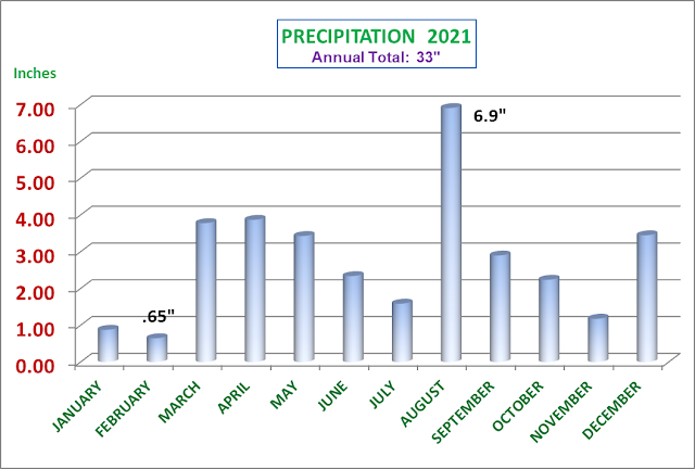
WINTER: started snowy in the fall with Octobers 8” of snow being the snowiest month of winter. Only 33” of snow fell.
JANUARY was the 12th warmest on record with no below zero temps. It had 4 thaws; the 6 day thaw mid month saw a run of upper 30’s. January is frequently the most sunny month but it was the cloudiest month of the year.
FEBRUARY for the 2nd year in a row it was colder than January; 11° colder. There were 13 below zero days with 131 consecutive hours below zero from the 11th to the 16th. Only 6” of snow.
MARCH was the 8th warmest & average precip. Record high 62° on the 9th with record dewpoint of 59°. Ample sun & only 3 ¾” of snow.
APRIL was cloudy with average temps & precip. The 10 days from the 6th to the 15th were cloudy with every day but 1 with precip. The 25th was the last freeze and last trace of snow.
MAY was pretty average which is pleasant. It started dry with only .1” of rain the first 18 days.
JUNE had 13 90° temps, it was the 2nd warmest & 8th driest on record. The 9 consecutive 90° days from the 3rd thru the 11th is the 3rd longest stretch of 90’s ever. It included the highest temp of the year, 99° on the 5th. 5 record warm highs & low temps were set.
JULY was warm & dry with 8 90° temps and only 5 days with rain totaling 1.6” The 28th had a sweltering 79 dewpoint & 107° heat index.
AUGUST continued warm & dry until 5” of rain fell the last week of the month making it the 9th wettest August. The 22nd and last 90° of summer was the 19th.
SEPTEMBER was the 16th warmest and 23rd driest with less than 3” of rain. Sept is reliably the most pleasant month in Minn to be outdoors.
OCTOBER was the 9th warmest. The low temps were 8° above average. Most of the global warming effect in Minn is warmer night time lows, especially in winter. The season’s first freeze was late on the 23rd.
NOVEMBER was the 2nd warmest on record and dry with only 1.2” of rain over 5 days. The first snow dropped a half inch on the 13th. About as pleasant as Nov can be.
Early WINTER of ’21– ‘22: Winter was a no show until 17” of snow dropped on the 11th. It was the 2nd snowiest Dec but above average temps.
DECEMBER A record high 54° on the 15th brought a snowless ground & a fire and wienie roast overlooking the Mississippi. It was a brown Christmas but true winter rolled in the last week with snow and the first below zero temp. A stout 30” of snow for the month.
Mr. Weatherbee Analytics

