|
Climbing Longs Peak
Journal Entries & Photographs From the Climb .
“Mountains Don’t Care”

Longs Peak is the Northernmost Fourteener in the Rocky Mountain chain. At 14,259 feet it is the Monarch of Northern Colorado and the 42nd highest peak in North America, 19th highest in the lower 48, and 16th highest in Colorado, home to 53 Fourteeners. Longs is the sentinel peak of Rocky Mountain N.P. and its only 14k mountain.
We base camped at Longs Peak campground at 9,405 feet. Clouds move in & out of nearby Twin Sisters peaks. Longs is shrouded in clouds. We ramped up a Minnesota oak and birch fire to burn through the heavy mist moving through the forest. The clouds turned pink as the sun set.
Excitement and anticipation dripped off the night for the adventure ahead. I have also climbed to the Keyhole on July 7 of ’87 but this Aug 1 day in ’84 is my first night camping in Rocky Mountain National Park and Longs will be my first hike in the park.
 |
| Longs Peak Canyon from Emerald Lake Hike |
 |
| LONGS PEAK, Granite Pass (Center), Mt. Lady Washington (L) |
THE FOREST: The alarm sounded at
4:00 a.m. – we did not respond. We
finally rolled out at 5:30 and carbed up on carob and chocolate chip cupcakes,
chocolate milk and vitamins. We stuffed
our pack and set off on the 14 mile climb at 6:08 with the onset of
twilight. My key equipment is water,
raincoat, gloves, flannel shirt, camera, journal, compass & map, carbs, and
hiking stick. The sky broke clear deep
blue with white cloud puffs as we marched through a thick green forest of Spruce,
Fir, and Ponderosa Pine.
 |
| INDIAN PAINTBRUSH |
 |
| COLUMBINE |
Longs Pk is a classic class III climb. 60 people have died
climbing it. I occasionally see the SARS rescue chopter head for Longs after
leaving its base in Beaver Meadows near my coveted top of the moraine campsite.
The first recorded ascent of Longs was John Wesley Powell and his survey party in 1868. The one armed Civil War General ran the Colorado River and his footprints are all over the West. Stephen Long was a member of the party and Longs Peak is named after him. Prior to this Major Long headed a military expedition up the Mississippi and recommended Fort Snelling be built at the confluence of the Minnesota & Mississippi Rivers.
The first recorded ascent of Longs was John Wesley Powell and his survey party in 1868. The one armed Civil War General ran the Colorado River and his footprints are all over the West. Stephen Long was a member of the party and Longs Peak is named after him. Prior to this Major Long headed a military expedition up the Mississippi and recommended Fort Snelling be built at the confluence of the Minnesota & Mississippi Rivers.

 |
| ALPINE BROOK |
The sun rose from behind the Twin Sisters casting the Forest in an eerie yellowish light. Soon the heat intensified as we peeled off clothing. We could hear the rushing of water and soon crossed over the tumbling cascading Alpine Brook, pregnant with snow melt. This is the main creek that drains the N.E. side of Longs. An alpine meadow flush with red Indian Paintbrush, blue Columbines and yellow Cone Flowers was a welcome relief from the endless BWCA like pine forest.
JIMS GROVE: As we climbed higher, successive rows of mountains rising from a shroud of moisture came into view. The Spruce & Fir get shorter with branches growing only on the side away from the wind. The landscape alters dramatically as only low growing shrubs like Englemann Spruce and Alpine Fir grow, sprinkled with dead Spruce trees that didn’t and couldn't make it.
The trees thinned out till they disappeared entirely; we had reached tree line. Tree line is the edge of alpine tundra. Trees will not grow when the average temperature of the warmest month is below 50 degrees. Tree line here is 11,500 feet (7,400 feet in Glacier N.P.). The Twin Sisters no longer fill the Eastern view.
 |
| Looking down into JIMS GROVE alcove |
We stopped for a rest and water here at Jim’s Grove, the last stand of impish Spruce and Fir set in a square block sized level alcove fronted by a crescent moon shaped steep snow field. The trail forked here; one trail going steeply up the snowfield and directly to Granite Pass, the other gently swooshing around Mt. Lady Washington’s base to Granite Pass.
We opted for the swoosh.
The sun was hot and burning in the thin alpine air. At the apex of the swoosh, or horseshoe arc,
we had a full frontal view of the East face of Longs Pk. The Diamond is a 1,000 foot world class
climbing motif. The massive granite face
terminates at Chasm Lake with a huge talus slope connecting the two. Mills Glacier runs down the edge of the talus
slope feeding the lake.
 |
| LONGS EAST FACE - The Diamond, Mills Glacier |
The wind rushes coldly over the rock ridge as the sun passes
over a nimbo-stratus cloud. We greet
several hikers who turned back because of the wind and cold. We shelter behind a granite boulder and make
friends with Chipmunks and Yellow-Bellied Marmots that began to appear seeking
treats. Older Marmots have a distinct
pine pollen yellowish tinge to their belly hair. The rest of the body is covered in medium to
dark brown fur similar to a beaver. It
is an excellent digger and hibernates for 9 months.
It weighs 12 pounds in Autumn, double its Spring weight. It looks a bit like a Beaver; but then both
are rodentia. Some sparrows flitted
about, 3 Elk grazed a meadow, Peregrines patrolled the sky, and a Pika chirped. The small rabbit eared mouse spends the short
6 week alpine summer gathering dry grasses and stashing them into its den
beneath rocky talus piles. It keeps warm with thick fur and high
metabolism. Even a few minutes in 70
degree air would overheat and kill it.
 |
| PIKA |
 |
| MARMOT |
 |
| PTARMIGAN |
Braided meltwater streams flowed swiftly from snowfields high above. The sun brought out the bright rainbow colors of the multitude of miniature flowers in this garden tundra. The high frequency clicking of a Ptarmigan emanates from nearby.
An intense detailed grid like vision search finally reveals the large grouse like bird only 4 feet away. It had 3 chicks in tow; hence the clicking to draw me away. The Ptarmigan was mottled light and dark brown with some remnant white spots. This is their summer coat and blends in perfectly with the lichen covered granite of the tundra. In fall their plumage turns completely white.

 |
| Can you see the Ptarmigan's head? |
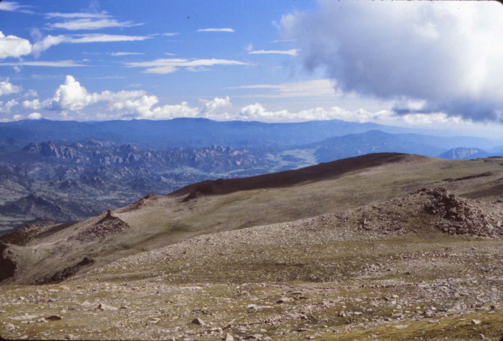
 GRANITE PASS: We push on and hike
beneath and around the base of Mt. Lady Washington. The rocky 13k talus peak looms directly over
us. The peak is named in honor of Anna
Dickinson who was the first woman to ascend Longs in 1873. She climbed Mt. Washington in New Hampshire
26 times. We reach Granite Pass at 12,080 feet and 4.2 miles from base
camp. This perch on the shoulder between
Battle Mt. and Longs affords a long Eastern view with rows of mountains
spreading out to the Great Plains beyond.
Ahead of us lay a spectacular valley with several snowcapped peaks. The next 1.7 miles switch backed steeply up
the mountain. We went straight up.
GRANITE PASS: We push on and hike
beneath and around the base of Mt. Lady Washington. The rocky 13k talus peak looms directly over
us. The peak is named in honor of Anna
Dickinson who was the first woman to ascend Longs in 1873. She climbed Mt. Washington in New Hampshire
26 times. We reach Granite Pass at 12,080 feet and 4.2 miles from base
camp. This perch on the shoulder between
Battle Mt. and Longs affords a long Eastern view with rows of mountains
spreading out to the Great Plains beyond.
Ahead of us lay a spectacular valley with several snowcapped peaks. The next 1.7 miles switch backed steeply up
the mountain. We went straight up.  |
| MT. LADY WASHINGTON fronts LONGS |
 |
| Looking Towards THE MUMMY RANGE from GRANITE PASS |
The ascent to the Boulder Field left us quite drained. The start of the Boulder Field sits at 12,760
feet and nearly 6 miles from base. It
sits on the back side of Mt. Lady Washington with a heads on view of the top of
the Diamond. Below the Keyhole is the
Agnes Vaille Shelter. Ms. Vaille was the
first woman to climb Longs Peak in winter.
She slipped on her descent in 1925 and fell 150 feet. She froze to death before her hiking partner
could bring back help. The stone memorial serves as an emergency shelter.


BOULDER FIELD: The Boulder Field is
a mile of haphazardly strewn boulders.
They are stacked on top of each other set at all angles ranging in size
from a stove to a garage. The boulders keep
getting bigger and rise higher to the coveted Keyhole. Footing is tenuous; a slip, an errant step in
a crack, or a rock shifting under foot could result in some nasty cuts or
worse, a broken ankle. It’s hard on the
feet.
 |
| BOULDER FIELD & Top of the DIAMOND |
There was a skeleton of a horse
that died a lonely and painful death after a hard journey. The “Corral” lies at the top of Granite Pass
at the base of the Boulder Field. The
wooden posts and cross pieces allow people who are too lazy to hike to tie up
their horse.
You get to know your feet very well as that’s all you look at,
one step after another. It reminds me of
some of the root and rock trails in the BWCA.
We slowly climbed the inclining boulders; scramble over 2 rock ridges, and
up the seemingly near vertical cliff of boulders to the Keyhole. This amazing perch is snuggled between the
peaks
of Long and Storm.
of Long and Storm.
 |
| Snow Field Running Up to the Keyhole |
 |
| Looking down the Boulder Field to Granite Pass from the Keyhole |
The KEYHOLE: Clouds ran into Longs
Pk and shot up and over it or took a Paul Giamatti route, which is to say they
went sideways. The Keyhole is a large irregular
hole chiseled out of the granite wall connecting Longs and Storm Peaks. It affords a ‘top of the world’ view and a
route to the top of Longs.
The notch of missing rock resembles a key. It also unlocks an amazing view of a valley of mountains unfolding beneath a tapestry of snowcapped peaks. The Mummy and Never Summer ranges appear with their crowns of snow. The snowcapped Gore Range and Williams Fork Mountains rise to the S.W. From the Keyhole it’s straight down over 3,000 feet to a canyon of lakes, waterfalls, snowfields, and glaciers surrounded by snowy peaks.
The notch of missing rock resembles a key. It also unlocks an amazing view of a valley of mountains unfolding beneath a tapestry of snowcapped peaks. The Mummy and Never Summer ranges appear with their crowns of snow. The snowcapped Gore Range and Williams Fork Mountains rise to the S.W. From the Keyhole it’s straight down over 3,000 feet to a canyon of lakes, waterfalls, snowfields, and glaciers surrounded by snowy peaks.
 |
| THE KEYHOLE |
 |
| FROZEN LAKE & McHENRY'S PK |
 |
| 70 mph Winds, 3,000' Drop at 13,250' |
 |
| KEYHOLE VIEW TO THE DIVIDE |
.
There is no way in and no way out except the way we came. A fall here would result in catastrophic
injury; let me define that – you’d be dead.
The air is cold, the sun burning; the thin air made physical exertion
difficult. The wind hits the canyon wall
and rushes through the Keyhole over 70 m.p.h.
We sit behind a portion of the wall to minimize the wind and snag some energy bars and water from our packs. At 13,250 feet we are 7 miles up mountain, low on energy, and fighting cold gale force winds. We see ice and snow in the Ledges and Trough. This makes it a technical climb from here requiring at a minimum an ice axe and crampons. We are at the end of our rainbow here.
We sit behind a portion of the wall to minimize the wind and snag some energy bars and water from our packs. At 13,250 feet we are 7 miles up mountain, low on energy, and fighting cold gale force winds. We see ice and snow in the Ledges and Trough. This makes it a technical climb from here requiring at a minimum an ice axe and crampons. We are at the end of our rainbow here.
WHITEOUT DESCENT: Given this and the
‘noon’ storm building and rolling in we headed back; a mile short of the top. It was 5 ½ hours up. Now we retrace our steps. The sun beamed on us as clouds moved in from
all directions. We were briefly basking
in sun through a ‘hole in the sky’ but soon thereafter walking in the clouds. There is no quick way out of the Boulder
Field; each step must be meticulously placed.
 |
| Clouds Slide off The Diamond |
The clouds enveloped us as we rolled down the mountain slope. We were in a near whiteout as snowfield meltwater rivulets moved quickly past us. We catch our breath at Granite Pass and are pelted with hailstones, sleet and rain as thunder roared. We can barely see the trail but lightning flashes upped the urgency quotient. We decide to go off trail for a straight shot down to Jims Grove.
 |
| Descending in the Clouds to Granite Pass |
We hike blindly down mountain and hit the top of the steep snowfield rimming the bowl of small spruce and fir of Jims Grove. We slide down the snowfield and into the protection of the tree line pygmy forest. We kicked up red snow. A red lichen grows in the snow, it is poisonous. Red anthracine converts UV rays to heat. We also spot some moths blown up the mountains from the plains and entombed in the snow crystals.
Three Elk graze on the mountain as we quickly descend through
the gnarled stunted forest. Battle Mtn.
disappears under tree line. We pass
through Goblins Forest, cross meadows and Alpine Brook, through miles of forest
to base camp. After an 8 hour nap we
emerge from our Eureka tent to ramp up a huge fire at midnight. I set up my Minolta camera under a canopy of
stars for time exposures. We see 14
meteors flashing across the dark sky.
Thin wispy patches of cirrus clouds dance through. A crescent moon riding low in the sky is about
to be extinguished by the Earth. Jupiter
shines and Coyotes call from the Twin Sisters. We add some pine and all of our
remaining wood to burn through the night.
We hear footsteps crunching the pea gravel outside our tent after
calling it a night.
We awoke to Bear footprints around our camp and in the dirt and dust on the bumper of our vehicle. It was a challenging and beautiful journey. We are but humans set in the grandeur of nature and must yield to her will. Nature shows no favoritism, preference or mercy; Mountains don’t care.
We awoke to Bear footprints around our camp and in the dirt and dust on the bumper of our vehicle. It was a challenging and beautiful journey. We are but humans set in the grandeur of nature and must yield to her will. Nature shows no favoritism, preference or mercy; Mountains don’t care.


 |
| '87 version of Hickory Hiker Straddling glacier between Otis Pk and Taylor Pk on the divide, a quick 700' slide down Andrews Glacier landed me at the foot of Andrews Tarn |
 |
| Pausing in Granite Pass on 1984 climb |