Wildcatting the RUBY RANGE
off trail traverse of the Ruby Mountains
Raggeds Wilderness
Gunnison National Forest
Crested Butte, Colorado, USA
Journal Entries & Photographs .
From the Hike

The Ruby Mountains in central Colorado are a colorful,
inspirational, spiritual Eden and make for memorable hiking/camping experiences. I pass through Gunnison (Sunny Gunny), pick
up some supplies, and roll up to Crested Butte.
Crested Butte, the out of the way skiing and biking haven for the
artistic neo hippy let it slide and ride Bohemians; way laid back and rich in
alpine scenery and local digs. The
suitcase and wallet crowd base a few miles up mountain at the ski resort. I’m
keeping it real with the townies.
My first order of biz is a homemade version of Mac’s
sausage, egg, muffin and hash browns at the Brothers Deli; a local gas
station/short order café. The same 2
chaps have been serving up the artery clogging chow and constant stream of witty
comments the past 8 years that I’ve come here.
I throw in a couple jabs that while unsolicited, were appreciated. I top it all off with a fresh grind cup of
dark roast.

 Crested Butte was a company town built to mine bituminous
coal in the area. Coal mining ended in
1852, the railroad pulled up the tracks down to Gunnison, and the economy crashed
until a ski run was opened in 1962.
About 1,500 people live in Crested, the ‘Wildflower Capital of
Colorado’. The speed limit is 15 m.p.h.,
what’s the rush; it is bike, ped, dog, and kid friendly. There is ‘Butte Time’ - it happens when it
will happen. There are no street lights
in Crested, curbs stray light pollution.
Crested Butte was a company town built to mine bituminous
coal in the area. Coal mining ended in
1852, the railroad pulled up the tracks down to Gunnison, and the economy crashed
until a ski run was opened in 1962.
About 1,500 people live in Crested, the ‘Wildflower Capital of
Colorado’. The speed limit is 15 m.p.h.,
what’s the rush; it is bike, ped, dog, and kid friendly. There is ‘Butte Time’ - it happens when it
will happen. There are no street lights
in Crested, curbs stray light pollution.
I take a stroll down the main drag, Elk Avenue, and take in
the building buzz. The 6 block long
street is lined with pastel colored Victorian 2 story houses from the late
1800’s to early 1900’s. A garage is sided with license plates while a
Bug parked in front of one house is covered with shoes. A young gal in a long pastel flower dress is
riding down the street on a classic one speed bike with a wire basket wired to
the back carrier which sits on top of the full fender. A young hipster in a green plaid shirt, black
denim shorts, tennies, and a green streak in his hair cruises past. An older gentleman has a cell pressed to his
ear.
It is mid-morning but this town ramps up slowly. I drop a few cards at the P.O., pick up a few
hats and shirts, and then stop in an old brown brick 1880 saloon that is now a
purveyor of fresh baked goods , coffee, sandwiches, and brews from the
microbrew across the street, the Eldo, which bills itself as ‘the sunny place
for shady people’. The ceilings are of
the 1880 style, very high and inlaid with engraved metal.
 |
| RED: hike to Green Lake BLUE: hike to Blue Lake |
 |
| Crested Butte-W. central Colo |
The weather is looking marginal so I head to Buckaroo Beanery to grab some java and information via my tablet. The radar shows light rain moving in from the West Elk Mountains. This is the excuse I need to sit in town and relax. I eat up some local news, baked goods & lattes while tuning in to the patter of the locals coming in for their java fix.
Two pals cross paths and one asks “How was your
summer”. This is an odd statement for
August 19th; the dog days of summer back in Minnesota but the onset
of fall in the high country. “I hope
this winter isn’t as bad as last year” the other chimes in. “Ya, hope we get a good snow pack” the first
one adds. Again, mega snow is a good
thing in a ski town; still it runs counter to my thinking. Brick Oven Pizza shop delivers slices to
Buckaroo at 11:00, another reason to extend my stay here.
 |
| Ruby Peak, Mt. Owen, & Purple Pk |
By mid afternoon the clouds thin so I roll the 8 miles of gravel forest road to Kebler Pass. The final 2 miles is a decent gravel road to Lake Irwin; a blue gem sitting at tree line at 10,400 feet. This campground is one of the highest developed campsites in the U.S. It is perched on a rocky hill above the lake among meadows and spruce and fir trees. The multi colored Ruby Range runs along the Western horizon a few miles away. The Anthracite Range dominates the southern view just across the valley. It is a rare range that runs East and West (Uinta’s in Utah is another).
 |
| Anthracite Range |
 |
| Extinct Volcano Carbon Pk |
The camp host goes site to site telling
everyone there’s a bear in camp. “Is
that necessary” I state in a flat line tone.
“Well in case they have kids and want to leave” the camp host says. The 4 wheeler guy tells the gals he has a gun
and to yell out if they see the bears.
What a frenzy, I thought maybe the Wolfman was loose. The naiveté is inexcusable. Last I checked we are in a Wilderness in a
National Forest – Bears live here, we don’t.


A crescent razor thin moon sets over the Ruby Range. I pull out the heavy BTU oak to mix with some snap, crackle, pop Pine to chase the chill that is certain to set in at this elevation. The skies are extremely dark and clear, the stars crisp. I see 4 meteors as the temp dives to 39 degrees by midnight. Well past midnight the land is quiet, broken by the sound of distant waterfalls in stereo; one pouring out of the Rubies and another exiting Lake Irwin. Porcupines and skunks were about.


A crescent razor thin moon sets over the Ruby Range. I pull out the heavy BTU oak to mix with some snap, crackle, pop Pine to chase the chill that is certain to set in at this elevation. The skies are extremely dark and clear, the stars crisp. I see 4 meteors as the temp dives to 39 degrees by midnight. Well past midnight the land is quiet, broken by the sound of distant waterfalls in stereo; one pouring out of the Rubies and another exiting Lake Irwin. Porcupines and skunks were about.

Fire and sky; the baseline experience since the dawn of man. Staying in one spot gives you a sense of place; otherwise it is like a photograph, a snapshot in time. In the San Miguel’s over the days I saw how the light hits the mountains in the morning, silhouettes out at sunset and see the sun dropping along the side of Middle Pk. A few days are but a slice of a season. It would be cool to see the landscape change in fast forward mode from Earth spinning up from a cloud of dust 4.5 billion years ago.
It is amazing to think that the galaxy as we see it is
expanding at an expanding rate.
Eventually it will stretch matter thinner and less dense until the
universe disappears. The sun, the earth,
people and even atoms will expand and pull apart into nothingness. But the matter we see is but 5% of the mass
of the universe; dark matter being 20% and the rest being dark energy.

I prep for my hike, load cold water, strap on the new
Vasque Sundowner hikers, check the camera, GPS, binocs, load up some carbs and
grab my hickory hiking stick. It’s time
to add 9 more miles to my lifetime hiking total. I whittle a band around my hiking stick for
every 500 miles hiked. I’ve logged 3,165
miles, far fewer than the near 15,000 miles on my bike but the miles just kind
of roll up on the bike.
Few of my lifetime miles are easy street such as the 24
mile round tripper with 9,000’ of elevation change to the bottom of the Grand
Canyon and out. It was 38° on the rim
and over 100° at the bottom. The last 3
miles out of the canyon climbed the Redwall in full sun at a 20% grade. Also memorable is the 14 miler to Longs Peak
Key Hole with 8,000’ of el change. The
weather went from sun to rain, snow, and ice pellets with a hike out down a
snowfield in a whiteout.
I also hiked 10 miles up Flattop Mountain in RMNP and
walked along the continental divide a few miles before glissading down Andrews
Glacier to a tarn while battling the onset of severe altitude sickness. Hiking
10 miles across the Utah desert in 100° heat to the confluence of the Green and
Colorado Rivers also stands out.
Climbing rope ladders into and out of red rock canyons added interest to
the hike. I also hiked along the Oregon
Coast for 10 miles; exploring caverns, tide pools, sea life, dodging crashing
waves and incoming tides. Oh wait, that
would be the definition of easy street, hey, even the Hickory Hiker needs some
down time.
I also notch a tepee in my hiking stick for every 100
nights camping out; I have notched 873 nights so far. My hiking stick is a solid piece of Shagbark
Hickory from Kipp S.P. in extreme S.E. Minnesota. A piece of leather is wrapped around the top
for a hand hold. I have a mini
thermometer and compass attached and a clip to attach bird feathers I find on
my hikes.
Todays hike is a wildcat off trail excursion masterminded
from the lounge chair in winter with the aid off topo maps and Google
Earth. I am in the Ruby Range
basin. This basin is separated from the
adjacent Oh-Be-Joyful valley and basin by a tundra ridge. This ridge would afford views into both
basins and long panoramic mountain top views; stellar stuff if it pans. As I found in the San Miguel’s, hiking the
terrain is different from mapping it. I
head cross country around a pond across undulating meadows with pockets of
Spruce and Fir trees. Iron in the soil
has oxidized turning it a light brown. The sun is out, the air calm and cold.
 The hike beta:
start elevation: 10,450’
end elevation: 11,855’
elevation delta: 1,405’
miles: 8.4’
average MPH up: 1.7
average MPH down: 2.8
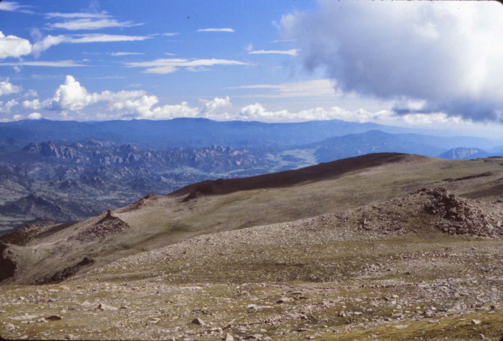
A Red Fox crosses my path. It is heading down to the lake. A Spruce Grouse ambles along in no particular hurry or direction, as grouse are want to do. The Ruby Range comes into full view. The Rubies top out over 13,000’ and are purple, cinnamon, maroon, and white. Rather than hike up the valley, I am striking cross country straight up and onto Ruby Peak to a bench or shelf that runs across its base to adjacent Mt. Owen. Landslides, snowfields, and serrated edges cascade steeply down to a line of firs and blooming meadows in a kaleidoscope of colors. A full on frontal view of the north end of the Anthracites looms large.
 |
| RUBY PK - 12,644' |

 |
| Ascending bench of Ruby Pk |
 |
| Westernmost Peak of ANTHRACITE RANGE |
 |
| Waterfall from GREEN LAKE |
 I hit tree line where the
Firs end and give way to Englemann Spruce and ground hugging Firs and cross the
base of an avalanche slope. Most years
the slope is a huge snowfield. I cross a
3 foot wide brook which splits a large meadow.
The brook cascades off a 40 foot chiseled purple cliff.
I hit tree line where the
Firs end and give way to Englemann Spruce and ground hugging Firs and cross the
base of an avalanche slope. Most years
the slope is a huge snowfield. I cross a
3 foot wide brook which splits a large meadow.
The brook cascades off a 40 foot chiseled purple cliff.A white moth with black bars along the front edges of its wings and black circles on its back wings sips nectar from a sunflower. Water, snow, rock; flowers are profuse with the sound of rushing water everywhere.


 |
| ASTERS |
 |
| Lake Irwin |
 |
| Nearing GREEN LAKE |
 |
| Rock close up |
 |
| COLUMBINE - Colorado State Flower |
 |
| GREEN LAKE |
The amazing blue-turquoise Green Lake fronts 2 large snowfields and a talus slope in a rocky bowl between Purple Pk and Mt. Owen. I breathe in the long views across Gunnison N.F., Lake Irwin and the cone shaped Carbon Pk. The entire Anthracite, Range is in full view rising from a deep green blanket of forest. Its 360 degrees of color and sound. The mountain pass looms steeply above. Staccato bursts of puffy cumulus range through the deep blue sky.
 |
| Wildcatting it across basin fronting Purple Pk. |
I backtrack down the talus slope to the basin fronting Mt. Owen. The Tundra ridge separating Oh-Be-Joyful valley rises a half mile across the basin. This is wildcat time. I survey the terrain and pick a route across the basin to the far ridge. A flock of Grey Jays passes through. I take a circular route up and over purple cliffs and climb to the high point in the saddle of the ridge.
 |
| PURPLE PK. |
I drop my pack in the short brown tundra grass dotted with wildflowers and take in a 360° view. I overlook the head of Oh-Be-Joyful valley, the basin I climbed up, and magnificent long and deep mountain top views that defy sensory processing. My view is hemmed in on one side by a line of 4 tundra topped purple cliffs. Each cliff has a long talus chute of purple rocks beneath it that meets the thinning forest as it blends tree line into tundra. Across the neck of the basin is symmetrical Gothic Mtn. with avalanche chutes dropping down from the peak.
 |
| On tundra ridge looking down Oh-Be-Joyful valley |
 |
| GOTHIC MTN |
The opposite valley ridge forms the N.E. wall of the valley and is infused with striations of white rock. Looking off towards Aspen and the Maroon Bells, peaks loom across the horizon, poking above the Joyful valley walls and the building cumulus cloud swatches.
I have forded the Slate River and hiked 4 miles up the Oh-Be-Joyful valley. The valley is a magnificent hike in its own right. The near peaks of Purple Peak, Afley Pk., Oh-Be-Joyful Pk., and Hancock Pk. form the 12 ½ thousand foot headwall of the valley. The ridge I’m on juts out into the valley. 800 feet directly below me is Blue Lake.
 |
| BLUE LAKE 800' below sits at the head of Oh-Be-Joyful valley |
Miles away Lake Irwin glistens in the sun like a jewel recessed into a dark green forest. The volcanic Anthracite Range looms as the northern outpost of the West Elk Mountains. The volcano Carbon Peak is silhouetted from the backlighting and wildfire smoke. The Ruby Range contains my view as it runs south into the Anthracites. The Ruby basin is a patchwork of meadows, cliffs, forest, and brooks.
A cold alpine breeze blows
up from the valley while my back cooks in the hot sun. The views and my thoughts are expansive. In my mind I am still that young buck who
could hike all day, jump creeks & crevices and scale landslide slopes. I am closer to the day I will be unable to do
this hike. My spirit will die long
before my physical shell. In some ways
it is too late to leverage that hard earned lifetime to advantage.
 |
| 4 miles up the Oh-Be-Joyful valley |
 |
| Head of Oh-Be-Joyful valley & Blue Lake |

It is an ironic quandary that as we get older we learn the possibility of our dreams with the wisdom and knowledge to attain them. Sadly we are locked in and too vested in the current path. It is too late, too risky to change the trajectory in any earth shattering meaningful way. As we get older there are fewer moments of pure joy, exhilaration, and triumph. The bonds of family and friends disintegrate and dissolve away like a fizzy in a cup of water.
The industrial age has
brought great wealth to man at the cost of our humanity. A more intimate interface with Earth and
nature is more fulfilling. Andrew
Carnegie controlled 1% of this country’s wealth in the 1880’s. It was built on the backs of men working 12
hour days 6 days a week. The gentler
kinder version is todays cubicle infused white collar information assembly
lines conducted inside fancy brick corporate headquarter buildings. It can breed contempt and dissatisfaction. As Thoreau pointed out, the ‘cost’ of
something is better measured in the time it takes to earn the money to purchase
said item. Our lives get consumed in the
minutia and infrastructure of modern life as we define it.
Increasing smart and
sophisticated software and nano, genetic, robotic technologies may render man
to the sidelines and largely irrelevant.
Man may largely be freed from ‘work’ but bulging populations, the strip
mining of earth & oceans of resources, pollution, a poisoned environment, and concentration of
wealth may leave no wild nature left to enjoy.
We will live in the cubicle of the new age; a garage sized concrete
bunker stacked end to end to infinity to efficiently house man. Our experiences with nature will all be
virtual; which is to say virtually nonexistent.
I stand here in this
magnificence and grandeur of nature.
This is why I am here on Earth.
Photography is my voice, my interface to the world. I never lived in a place that I’d call home;
but this is home; and life sustaining.
This view is much the same as it was a century ago. Time becomes the here and now. Everything else either has happened or will
happen. The Sun & Moon move across
the sky at a slightly shallower or higher arc each day. These are the demarcations of time. Calendars and clocks become irrelevant. Time is malleable like the Salvador Dali
watch.
Sitting on the mountain top
is me stealing the nexus; the nectar of the landscape. In a sense it is not pure for I am but a
visitor. The sun is shining, the sky is
blue, tundra grasses and flowers hug the earth, white puffs of cumulus march
across the sky with their shadows moving in lockstep across the massive
landscape. This is life and I am alive.
 |
| Descending from the saddle |
I track back slowly to camp. The grand views incrementally dissolve as I
descend; like an ore carrier disappearing over the Lake Superior horizon. I lounge and snack too long at camp. I rush to Crested and just miss the U.S.A.
Pro Cycling Challenge riders cruising through town by 10 minutes. Lance Armstrong was in town yesterday. He ran from his digs in Aspen across the
mountains to Crested and back. It
certainly has to be a 30 mile run (it’s a 160 miles to drive to Aspen). He bought a hotel in Aspen and converted it
into his personal enclave. It is true,
the billionaires have pushed the millionaires out of Aspen. As long as I’m in town I hit the Buckaroo
Beanery and grab a few supplies (supplies meaning snacks).
 |
| BECKWITH MTN. |
On the drive back through Kebler Pass, on the Eastern end
of the Anthracite Range, I saw the Mama Bear and 2 Cubs in a meadow about 5 miles
from camp. A Bears’ sense of smell is
2,000 times better than humans; they can smell raw meat from 20 miles away. A group of Peruvians herd sheep down the
road, presumably to greener pastures. White Beckwith Mountain rises from the forest
to the south.
 |
| Bears in Kebler Pass |
The gals freaked out and
went for their car, turning on the head lights and honking the horn (it is 1
a.m.). My campsite was across from the
dumpster so I watched the show. The
bears caused quite a ruckus, ran around tents, people screaming, they hauled
off a cooler, walked up the dirk bike ramp lowered from a school bus, dogs
going crazy. People are funny, it did a
good job of clearing the camp out. Attention National Forest
Mgmt: Hey, I’m paying fees here, how ‘bout
getting some bear proof dumpsters in here; and pick up the trash once in a
while. This situation is abzurd,
redonkulousness squared.
I tracked back to camp
after leaving Crested in time to catch the Earth’s orbital velocity spin it out
of view of the sun, otherwise known as sunset.
The Anthracite Range is silhouetted in a smoky grey haze. At this elevation above 10,000 feet the temp
drops quickly. I crank up a fire as the
stars spin up. The crescent moon sinks
below the Ruby Mountains through a thin stand of Spruce trees shortly after
darkness sets in with Mars, Saturn, and Spica clustered with it. All is in balance; the Earth and my Spirit
are in alignment.
 |
| Slice of a Rainbow |
MORNING in the MOUNTAINS
Morning comes in 2 phases; early & late, yin & yang,
waxing & waning. Early morning light
leaking onto the landscape brings a tranquil contemplative mindset. Colors are muted, the atmosphere calm and
moist; sharpening the earthy smells that emanate. The earth quietly spins on its’ axis, birds
and animals go about their business.
The demarcation between early and late morning is sublime; a
movable imprecise timeline; a passing noted after the fact. It is an event brought to consciousness by
the peeling off of a long sleeve shirt, a bright
sun past 35 degrees of declination, sunglasses, staccato bursts of warm wind
blowing through the dying embers of the morning fire, a background soundscape
muddied increasingly by humans and their machines, the appearance of patchy low
key stratus clouds scraping across a powder blue sky and a time piece that
reads 10:15.
Early morning is a creative time to nourish the soul and to drink
in the nectar of the earth.


mef


mef